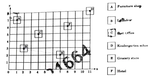
A rough co-ordinate map of Lahiri's locality is shown below :

The distance between the hotel and the post office is :
5 units
√5 units
√17 units
17 units
Step by step video & image solution for A rough co-ordinate map of Lahiri's locality is shown below : The distance between the hotel and the post office is : by Maths experts to help you in doubts & scoring excellent marks in Class 10 exams.
Related Playlists
- BOOK - X BOARDSCHAPTER - QUESTION PAPER 2022 TERM 1 SET 2 BASICEXERCISE - SECTION B20videos
QUESTION PAPER 2022 TERM 1 SET 2 BASIC
- BOOK - X BOARDSCHAPTER - QUESTION PAPER 2022 TERM 1 SET 1 STANDARDEXERCISE - SECTION-C (CASE STUDY)10videos
QUESTION PAPER 2022 TERM 1 SET 1 STANDARD
- BOOK - X BOARDSCHAPTER - QUESTION PAPER 2022 TERM 1 SET 2 STANDARDEXERCISE - SECTION-C10videos
QUESTION PAPER 2022 TERM 1 SET 2 STANDARD
Knowledge Check
- Question 1 - Select One
Riya walked 90 m towards the north from her house, and then took a right turn and walked 60 m to reach the market. Then, she took a left turn and walked a few meters from the market to reach the post office, from where she took a left turn again and walked 160m to reach the school. If the air distance between Riya’s house and the school is 260 m, what is the air distance between the market and the post office?
A180 mB120 mC150 mD100 m - Question 1 - Select One
The co-ordinator between Nervous and endocrine system is
AThalamusBHypothalamusCEpithalamusDColliculus - Question 1 - Select One
On a map, half centimetre shows 125 kilometres on the ground. If two cities are actually 2000 kms apart on the ground, then the distance between them on the map is (in cm) :
A6B8C10D4 - Question 1 - Select One
The post office is to the east of the school while my house is to the south of the school. The market is to the north of the post office. If the distance of the market from the post office is equal to the distance of my house from the school. In which direction is the market with respect to my school ?
ANorthBEastCNorth-EastDSouth-West - Question 1 - Select One
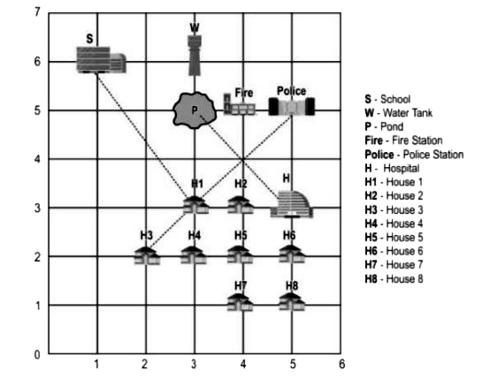
Shown below is a town plan on a coordinate grid, where 1 unit = 1 km. Consider the co-ordinates of each building to be the point of intersection of the respective grid lines.

What is the distance between the school and House 1 along the path shown?A√13 kmB√97 kmC13 kmD97 km - Question 1 - Select One
On a city map it was mentioned "Scale 1 cm = 110 m". If the distance between two localities on the map is 15 cm, then the actual distance between the two localities
A1.65 kmB1165 cmC1100 mD1500 m
Similar Questions
Riya walked 90 m towards the north from her house, and then took a right turn and walked 60 m to reach the market. Then, she took a left turn and walked a few meters from the market to reach the post office, from where she took a left turn again and walked 160m to reach the school. If the air distance between Riya’s house and the school is 260 m, what is the air distance between the market and the post office?
View SolutionCo-ordinate of A is at 5 unit and if co-ordinate of B is -6 unit then find distance between AB.
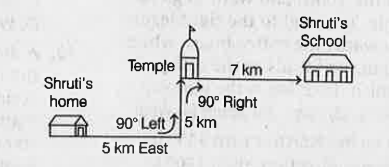
View SolutionThe map of Shruti's journey from her home to school is given below On the basis of abovemap, answer the questions given below.
 on the basis of above map answer the questions given below.
The shortest distance between Shruti's school and her home isView SolutionThe post office is to the east of the school while my house is to the South of the school. The market is to the North of the post office. If the distance of the market from the post office is equal to the distance of my house from the school, in which direction is the market with respect to my school ?
View Solution

