The distance between two cities A ad B in a map is 7.5 cm. the scale taken for drawing this map is 1cm=1,50,000m. The actual distance between A and B is____km.
1125000
20000
200
1125
The correct Answer is:D
Step by step video, text & image solution for The distance between two cities A ad B in a map is 7.5 cm. the scale taken for drawing this map is 1cm=1,50,000m. The actual distance between A and B is____km. by Physics experts to help you in doubts & scoring excellent marks in Class 7 exams.
Updated on:21/07/2023Topper's Solved these Questions
- MEASUREMENTSBook:PEARSON IIT JEE FOUNDATIONChapter:MEASUREMENTSExercise:Test Your Concepts (Very Short Answer Type Questions (Match the column))
Explore 2 Videos
- MEASUREMENTSBook:PEARSON IIT JEE FOUNDATIONChapter:MEASUREMENTSExercise:Test Your Concepts (Very Short Answer Type Questions)
Explore 21 Videos
- MEASUREMENTSBook:PEARSON IIT JEE FOUNDATIONChapter:MEASUREMENTSExercise:Test Your Concepts (Very Short Answer Type Questions) (Fill in the blanks))
Explore 8 Videos
- MACHINES AND TOOLSBook:PEARSON IIT JEE FOUNDATIONChapter:MACHINES AND TOOLSExercise:CONCEPT APPLICATION (LEVEL 2)
Explore 12 Videos
- MOCK TESTBook:PEARSON IIT JEE FOUNDATIONChapter:MOCK TESTExercise:MULTIPLE CHOICE QUESTION
Explore 25 Videos
Similar Questions
The distance between City A and City B on a map is given as 6 cm. If the scale represents 1 cm = 200 km, then find the actual distance between City A and City B
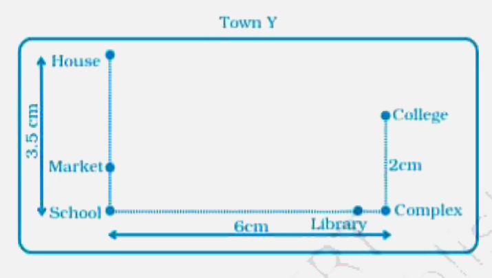
View SolutionUse a ruler to measure the distance in cm between the places joined by dotted lines. If the map has been drawn using the scale 1 cm :10 km, find the actual distances between
(1) School and Library
(2) College and Complex
(3) House and School

View Solution
Knowledge Check
The distance between two cities A ad B in a map is 7.5 cm. the scale taken for drawing this map is 1cm=1,50,000m. The actual distance between A and B is____km.
A1125000B20000C200D1125Distance between two linked genes is measured fin map units that depict
ARatio of crossing over between themBCross over valueCNumber of genes between themDBoth B and CThe distance between school and house of a girl is given by 5 cm in a picture, using the scale 1 cm:5 km. Find the actual distance between the two places?
A5 kmB20 kmC10 kmD25 km
The distance between school and house of a girl is given by 5 cm in a picture, using the scale 1 cm : 5 km. Find the actual distance between the two places?
View SolutionIf actual distance between two places A and B is 110 km and it is represented on a map by 25 mm. Then the scale used is ______.
View SolutionThe genes A,B,C and d are located on the same chromosome in such a way that the distance between A and B is 7 map units, between B an C is 2 map is unit, between C and D is. 4.5 units. What is the distance between A and D? What is the porbability of linkage between B and D and between A and D?
View SolutionThe distance between two places is 12 km. A map scale is 1:25000.
The distance between the two places on the map, (in cm) is
View SolutionThe distance between two places is 12 km. A map scale is 1 : 25000. The distance between the two places on the map, in cm is
View Solution
